- Login
Thomas Kitchin (British, 1718 - 1784)
Item 1 of 1
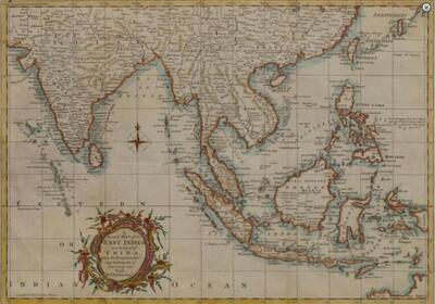
| A general map of the East Indies and that part of China where the Europeans have any settlements or commonly any trade | |
| Thomas Kitchin (British, 1718 - 1784) | |
| 483 | |
£250 -
£350 | |
| Copper engraving with hand-colouring | |
| Sculptures | |
| 31 cm - 42.5 cm (12.2 in - 16.73 in) | |
| Signed | |
| Fine Art featuring Fine European Ceramics | |
| Dec 05, 2017 |
A general map of the East Indies and that part of China where the Europeans have any settlements or commonly any trade
483
£250 -
£350
Copper engraving with hand-colouring
Sculptures
31 cm -
42.5 cm (12.2 in -
16.73 in)
Signed
Dec 05, 2017